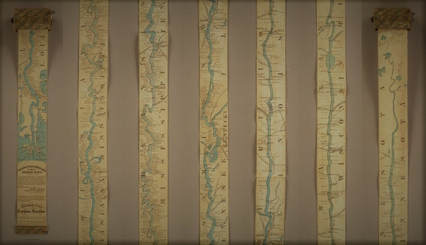
Everybody knows a fact or two about the United States of America, even those who've never set foot there. At the very least, they know the US is a big country, but it's one thing to know that and another to truly understand the scale involved. Today we offer you an artifact from cartographic history that illustrates it vividly: a 19th-century traveler's map of the Mississippi River that, in order to display the length of that mighty 2,320-mile waterway, extends to a full eleven feet. (Or, for those especially unfamiliar with how things are in America, displays the river's full 3,734-kilometer length at a full 3.35 meters.)
With a width of only three inches (or 7.62 centimeters), the Ribbon Map of the Father of Waters came on a spool the reader could use to unroll it to the relevant section of the river anywhere between the Gulf of Mexico and northern Minnesota. First published in 1866, just a year after the end of the Civil War, the map "was marketed toward tourists, who were flocking to the Mississippi to see the sights and ride the steamboats." So writes Atlas Obscura's Cara Giamo, who quotes art historian Nenette Luarca-Shoaf as describing the river as “a source of great awe. That kind of length, that kind of spaciousness was incomprehensible to a lot of folks who were coming from the East Coast."
0 Comments
Leave a Reply. |
NewsArchives
February 2020
|
 RSS Feed
